


HUTCHINS - T 1 Voting District, Shawano County, Wisconsin
About
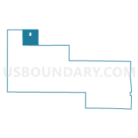
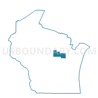
Outline

Summary
| Unique Area Identifier | 697018 |
| Name | HUTCHINS - T 1 Voting District |
| County | Shawano County |
| State | Wisconsin |
| Area (square miles) | 33.51 |
| Land Area (square miles) | 33.40 |
| Water Area (square miles) | 0.10 |
| % of Land Area | 99.69 |
| % of Water Area | 0.31 |
| Latitude of the Internal Point | 44.98265320 |
| Longtitude of the Internal Point | -89.03429090 |
Maps

Graphs
Select a template below for downloading or customizing gragh for HUTCHINS - T 1 Voting District, Shawano County, Wisconsin


Neighbors
Neighoring Voting District (by Name) Neighboring Voting District on the Map
- ALMON - T 1 Voting District, Shawano County, WI
- ANIWA - T 1 Voting District, Shawano County, WI
- BARTELME - T 1 Voting District, Shawano County, WI
- BIRNAMWOOD - T 2 Voting District, Shawano County, WI
- Mattoon - V 1 Voting District, Shawano County, WI
- MENOMINEE - T 2 Voting District, Menominee County, WI
- NORWOOD - T 1 Voting District, Langlade County, WI
- NORWOOD - T 2 Voting District, Langlade County, WI
- ROLLING - T 2 Voting District, Langlade County, WI
Top 10 Neighboring County Subdivision (by Population) Neighboring County Subdivision on the Map
- Menominee town, Menominee County, WI (4,232)
- Rolling town, Langlade County, WI (1,504)
- Norwood town, Langlade County, WI (913)
- Bartelme town, Shawano County, WI (819)
- Birnamwood town, Shawano County, WI (763)
- Hutchins town, Shawano County, WI (600)
- Almon town, Shawano County, WI (584)
- Aniwa town, Shawano County, WI (541)
- Mattoon village, Shawano County, WI (438)
Top 10 Neighboring Place (by Population) Neighboring Place on the Map
Top 10 Neighboring Unified School District (by Population) Neighboring Unified School District on the Map
- Antigo School District, WI (17,774)
- Wittenberg-Birnamwood School District, WI (7,837)
- Menominee Indian School District, WI (4,232)
- Bowler School District, WI (2,467)
Top 10 Neighboring State Legislative District Lower Chamber (by Population) Neighboring State Legislative District Lower Chamber on the Map
Top 10 Neighboring State Legislative District Upper Chamber (by Population) Neighboring State Legislative District Upper Chamber on the Map
Top 10 Neighboring 111th Congressional District (by Population) Neighboring 111th Congressional District on the Map
Top 10 Neighboring Census Tract (by Population) Neighboring Census Tract on the Map
- Census Tract 1008, Shawano County, WI (4,860)
- Census Tract 1006, Shawano County, WI (4,240)
- Census Tract 9604, Langlade County, WI (3,930)
- Census Tract 1007, Shawano County, WI (3,423)
- Census Tract 9401.02, Menominee County, WI (2,857)